(84 - 28) 62970345
Surveying
This high definition surveying (HDS) method or laser scanning is primarily responsible for capturing high quality and speed data of a building or an object that is difficult to see with the naked eye. These laser beams that are emitted in the scanning process grab millions of each and every pixel of an object with high accuracy. These are used to measure bridges, buildings, roadways, etc. These eye-safe beams then grab the accurate X, Y, and Z, values in minutes.
Portcoast Digital Transformation Center is proud to be the leading 3D Laser service provider in Vietnam. Along with our experience and constantly updated equipment, we will bring to our customers the best and most accurate survey quality. We offer a comprehensive service including onshore and underwater topographical surveying..
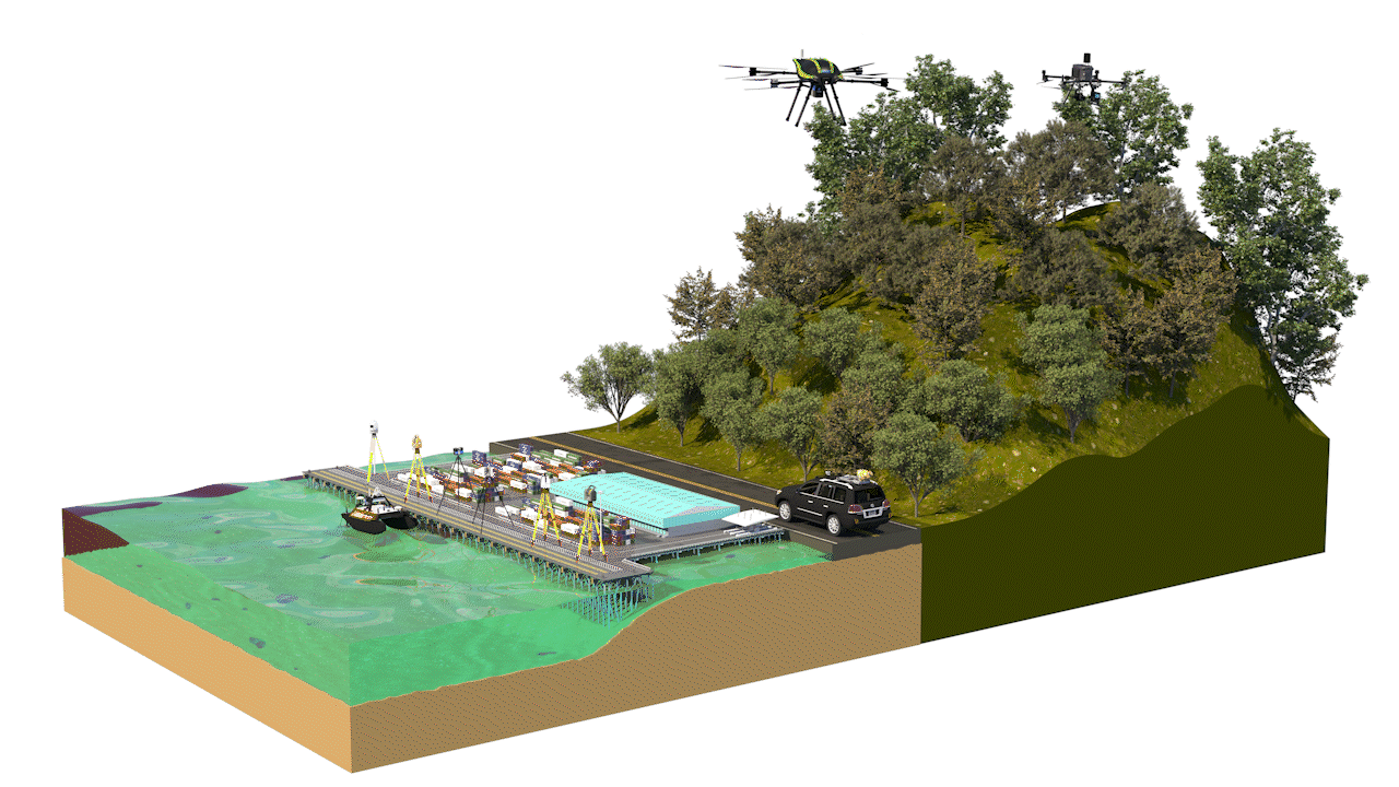
Portcoast Digital Transformation Center specializes in providing surveying services to collect topographic data by UAV/Drone unmanned aerial vehicle. With LiDAR technology on the drone has simplified the whole surveying process, safer and cost-effective.
Portcoast Digital Transformation Center specializes in providing 3D Laser surveying services. We collect a large amount of field information in a very short period of time. The process works by capturing a series of high-definition 3D laser scans in situ that can be instantly processed for analysis.
Through the scanning process, millions of 3D points are recorded within seconds and a 3D point cloud is created. Full 3D data of pitch, measurements, coordinates, pipe diameters, and high definition images can be extracted with one click.
Mobile Mapping is the process of collecting geospatial data using mapping sensors mounted on moving platforms such as cars, marine vessels or airplanes.
Portcoast Digital Transformation Center has experience in performing mobile mapping surveys to collect 3Dpoint cloud, 360° photography, high definition video and thermal imagery for the route corridor.
Surveying and mapping tools needed to monitor coastal erosion, measure and map navigable waters, monitor coastlines and beaches, and provide data for programs storm damage, depth and mass calculations for dredging projects, locating and mapping submerged obstacles, and preparing for underwater and shoreline construction.
Hydrographic survey services we perform include: single beam sonar, multibeam sonar, side scan sonar, magnetometer, sub-bottom profiling,..
Our state-of-the-art equipment

Trimble MX50 Mobile Mapping System
The Trimble MX50's is a practical field to finish moblie mapping solution for asset management, mapping, road maintenance. Mobile mapping system combining precise LiDAR data and immersive panoramic imagery at highway speed..

Polaris Terrestrial Laser Scanner (TLS)
With an integrated high-resolution camera, inclinometers, compass, GPS receiver, and weather-proof housing, the Polaris can be deployed in many environments and orientations.

Stormbee UAV S-20
STORMBEE is a user-friendly Unmanned Aerial Vehicle (UAV) custom designed for lasers canning with a FARO Focus laser scanner.

Matrice 300 RTK + Zenmuse L1 + Zenmuse P1
This is one of the most advanced drones. Equipping sensors in multiple directions gives the Matrice 300RTK outstanding safety. The Matrice 300RTK - Zenmuse L1 system is capable of capturing image and point cloud data, based on 3 times response signal from the Lidar and penetrating through the foliage…

Matrice 300 RTK + Share PSDK 102S V3
PPSDK 102S V3, the 5-lens oblique camera with 3-Axis Stabilized Gimbal, is a highly integrated surveying camera specialized in aerial photogrammetry. Full-on efficiency booster brings unprecedented operating experience. The adjustable parameter allows camera applicated in various scenarios. Also widely compatible with open-source payloads.

Otter Pro USV + Norbit iWBMS Multibeam Sonar & iLiDAR
The OTTER Pro had integrated system between a Norbit's iWBMS Multibeam and a NORBIT's iLiDAR Laser Sensor to recorded underwater data and both sides. This system is an efficient solution (reduce cost and schedule) for surveying in shallow water areas such as lakes, canals, rivers, ponds and harbour areas.

Trimble SX12 Scanning Total Station
Trimble SX12 Scanning Total Station working harder has never been easier. It combines innovative technology with simple and intuitive functionality to help you save time, maximize efficiency and get more done in the field.

Leica Scanstation P50
For industry professionals looking to scan inaccessible places and find new business opportunities, Leica ScanStation P50 is the fastest and safest, long range 3D laser scanner. Unlike any other laser scanner, the P50 solution maximises productivity by scanning inaccessible places at a safe position on site, reducing time in the field with less setups.

Leica RTC360 3D Laser Scanner
The Leica RTC360 3D reality capture solution empowers users to document and capture their environments in 3D, improving efficiency and productivity in the field and in the office through fast, simple-to-use, accurate, and portable hardware and software.

Leica iCON iCR80 Robotic Total Station
The Leica iCON iCR80 construction total station keeps its ‘eye’ on only one thing: the user’s target. Layout more points per day thanks to ATRplus, the most robust automated-aiming, lock and re-lock technology in the market.

Leica Nova TS60 Total Station
The new Leica Nova TS60 total station is the world’s most accurate total station, designed to tackle your most demanding projects.

Topcon GLS-2200
Quickly tackle any job with the latest in scanning and workflow technology. The GLS-2200 features a unique survey style setup and user-friendly processing software that turn lengthy scanning processes into fast and easy workflows

FARO Focus S350-A 3D Laser Scanning
The FARO Focus S350-A is specially designed for outdoor applications due to its small size, extra light weight and extended scanning range. The Focus S350-A provides scanning results even in challenging environments, narrow job-sites, dusty or humid areas, in rain or direct sunlight applications.

MatterPort Pro 2
Matterport is the standard for 3D space capture. Our all-in-one platform transforms real-life spaces into immersive digital twin models.

Unitree Go1 Plus & Leica BLK 360
Unitree Go 1 is a quadrupedal mobile robot offering lots of development possibilities. It’s aimed in particular at higher education and professionals, for developing applications in fields ranging from service robotics to autonomous surveillance.
Portcoast Digital Transformation Center
We provide digital conversion services in the construction industry. We research ways to apply digital conversion to the world of design and construction, creating a digital platform to optimize design, promote industrial construction processes, and use digital models.
Contact Us
328 Nguyen Trong Tuyen Str., Ward 2, Tan Binh Dist. , Ho Chi Minh City
(84 - 28) 62970345; 62970341
portcoast@portcoast.com.vn