(84 - 28) 62970345
Aerial Survey (UAV/Drone)

Stormbee UAV S-20
STORMBEE is a user-friendly Unmanned Aerial Vehicle (UAV) custom designed for lasers canning with a FARO Focus laser scanner.
View in 3D
Matrice 300 RTK + Zenmuse L1 + Zenmuse P1
This is one of the most advanced drones. Equipping sensors in multiple directions gives the Matrice 300RTK outstanding safety. The Matrice 300RTK - Zenmuse L1 system is capable of capturing image and point cloud data, based on 3 times response signal from the Lidar and penetrating through the foliage…
View in 3D
Matrice 300 RTK + Share PSDK 102S V3
PSDK 102S V3, the 5-lens oblique camera with 3-Axis Stabilized Gimbal, is a highly integrated surveying camera specialized in aerial photogrammetry. Full-on efficiency booster brings unprecedented operating experience. The adjustable parameter allows camera applicated in various scenarios. Also widely compatible with open-source payloads.
View in 3D
DJI Matrice 30T
Professional drones are used for monitoring, geographic analysis, object detection and identification, etc. They feature multi-layer sennosor systems, super-natural cameras, GPS positioning systems, remote control capabilities, and connectivity with mobile devices.

DJI Phantom 4 RTK
Professional drones are used for monitoring, geographic analysis, object detection and identification, etc. They feature multi-layer sennosor systems, super-natural cameras, GPS positioning systems, remote control capabilities, and connectivity with mobile devices.
3D Laser Scanning

Trimble SX12 Scanning Total Station
Trimble SX12 Scanning Total Station working harder has never been easier. It combines innovative technology with simple and intuitive functionality to help you save time, maximize efficiency and get more done in the field.
View in 3D
Polaris Terrestrial Laser Scanner (TLS)
With an integrated high-resolution camera, inclinometers, compass, GPS receiver, and weather-proof housing, the Polaris can be deployed in many environments and orientations.
View in 3D
Leica Scanstation P50
For industry professionals looking to scan inaccessible places and find new business opportunities, Leica ScanStation P50 is the fastest and safest, long range 3D laser scanner. Unlike any other laser scanner, the P50 solution maximises productivity by scanning inaccessible places at a safe position on site, reducing time in the field with less setups.
View in 3D
Leica RTC360 3D Laser Scanner
The Leica RTC360 3D reality capture solution empowers users to document and capture their environments in 3D, improving efficiency and productivity in the field and in the office through fast, simple-to-use, accurate, and portable hardware and software.
View in 3D
Topcon GLS-2200
Quickly tackle any job with the latest in scanning and workflow technology. The GLS-2200 features a unique survey style setup and user-friendly processing software that turn lengthy scanning processes into fast and easy workflows
View in 3D
FARO Focus S350-A 3D Laser Scanning
The FARO Focus S350-A is specially designed for outdoor applications due to its small size, extra light weight and extended scanning range. The Focus S350-A provides scanning results even in challenging environments, narrow job-sites, dusty or humid areas, in rain or direct sunlight applications.
View in 3D
Unitree Go1 Plus & Leica BLK 360
Unitree Go 1 is a quadrupedal mobile robot offering lots of development possibilities. It’s aimed in particular at higher education and professionals, for developing applications in fields ranging from service robotics to autonomous surveillance.
View in 3D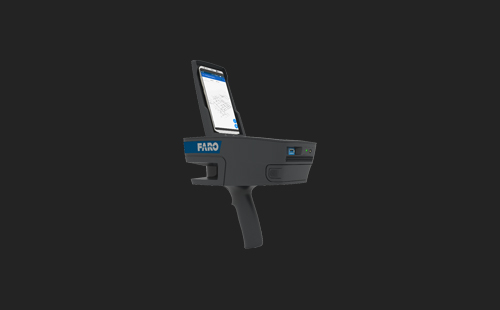
FARO ScanPlan 2D Handheld Mapper
FARO ScanPlan 2D Handheld Mapper is a portable and easy-to-use device that allows users to create 2D floor plans of interior space.
View in 3DRobotic Total Station & Digital Levels

Leica iCON iCR80 Robotic Total Station
The Leica iCON iCR80 construction total station keeps its ‘eye’ on only one thing: the user’s target. Layout more points per day thanks to ATRplus, the most robust automated-aiming, lock and re-lock technology in the market.
View in 3D
Leica Nova TS60 Total Station
The new Leica Nova TS60 total station is the world’s most accurate total station, designed to tackle your most demanding projects.
View in 3D
Leica LS10 Digital Levels
Leica LS10 Digital Levels alleviate demanding levelling tasks on any site. Automated functions and industry-leading 0.2mm accuracy allow users to easily demonstrate their measuring skills while effectively completing any project.
View in 3D
Trimble DiNi Level
The Trimble DiNi Level is a digital height measurement sensor from Trimble’s Integrated SurveyingTM portfolio. The Trimble DiNi is a field-proven tool designed for any job site requiring fast and accurate height determination. Use the Trimble DiNi for applications such as precise leveling of flat and sloping surfaces, establishing the vertical component of grade and ground profiles, subsidence monitoring, and establishing the vertical component of control networks.
View in 3DGPS/GNSS RTK
Leica iCON GPS 70 Series
The Leica iCON GPS 70 Series is a line of high-precision GNSS (Global Navigation Satellite System) receivers designed for surveying, construction, and engineering applications.
View in 3D
Leica GS18 T - GNSS RTK Rover
The Leica GS18 T is a global navigation satellite system (GNSS) receiver manufactured by Leica Geosystems. With optional RTK and IMU technology, the Leica GS18 T enables high-precision data collection and faster positioning compared to other traditional surveying tools. It is also integrated with features such as water, dust, and shock resistance, allowing it to operate well in harsh environments.
View in 3D
Leica GS18I – GNSS RTK Rover
The Leica GS18I is a high-end Global Navigation Satellite System (GNSS) data collection system produced by Leica Geosystems. The device uses Inertial Measurement Unit (IMU) technology to measure the inclination and position of the sensor, providing accurate positioning data even in challenging environments such as areas with complex terrain or construction sites with many obstacles.
View in 3D
Trimble R12i GNSS + Trimble TSC7
The Trimble R12i GNSS is a high-end Global Navigation Satellite System (GNSS) produced by Trimble. It is designed to provide high accuracy, reliability, and superior performance in high-precision positioning applications such as construction, land surveying, scientific research, agriculture, and other industries.
View in 3D
Topcon HiPer V
Topcon HiPer V is a global navigation satellite system (GNSS) receiver produced by Topcon Positioning Systems. It is also equipped with RTK and IMU technology, allowing for high-precision data collection and fast positioning.
View in 3DMobile Mapping System

Trimble MX50 Mobile Mapping System
The Trimble MX50's is a practical field to finish moblie mapping solution for asset management, mapping, road maintenance. Mobile mapping system combining precise LiDAR data and immersive panoramic imagery at highway speed..
View in 3D
Polaris Terrestrial Laser Scanner (TLS)
With an integrated high-resolution camera, inclinometers, compass, GPS receiver, and weather-proof housing, the Polaris can be deployed in many environments and orientations.
View in 3DHydrographic Survey

Otter Pro USV + Norbit iWBMS Multibeam Sonar & iLiDAR
The OTTER Pro had integrated system between a Norbit's iWBMS Multibeam and a NORBIT's iLiDAR Laser Sensor to recorded underwater data and both sides. This system is an efficient solution (reduce cost and schedule) for surveying in shallow water areas such as lakes, canals, rivers, ponds and harbour areas.
View in 3D
EdgeTech 3200-XS Sub-bottom Profiling
EdgeTech 3200-XS Sub-bottom Profiling System is a high-resolution wideband Frequency Modulated (FM) sub-bottom profiler utilizing EdgeTech’s proprietary Full Spectrum CHIRP technology. The system transmits a FM pulse that is linearly swept over a Full Spectrum frequency. The acoustic return received at the hydrophones is passed through a pulse compression filter, generating high-resolution images of the sub-bottom stratigraphy in oceans, lakes, and rivers.
View in 3D
EdgeTech 4200-MP Side Scan Sonar
EdgeTech 4200-MP Side Scan Sonar System provides a unique advantage over conventional dual frequency side scan systems by combining EdgeTech’s Full Spectrum and Multi-Pulse technologies into one unit. Providing high resolution images of seabed in oceans, lakes and rivers.
View in 3D
Nortek AWAC
Nortek AWAC is a type of device used to measure the flow of seawater or flow in other water environments. The device uses sound waves to measure the velocity and direction of water flow.
View in 3D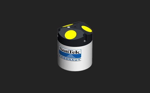
Sontek Agonaut-XR
Sontek Agonaut-XR is a type of water flow measuring device produced by Sontek company. It is one of the compact handheld water flow measuring devices. This device uses pressure measurement technology and monitoring software to measure the flow velocity of water.

Sontek Agonaut-ADV®
Sontek Agonaut-ADV® is a system for collecting underwater flow measurement data produced by the company Sontek/ Xylem Inc. This system is designed to measure velocity, depth, temperature, salinity, oxidation, and other parameters of water in freshwater and saltwater environments.
View in 3DBrands


Portcoast Digital Transformation Center
We provide digital conversion services in the construction industry. We research ways to apply digital conversion to the world of design and construction, creating a digital platform to optimize design, promote industrial construction processes, and use digital models.
Contact Us
328 Nguyen Trong Tuyen Str., Ward 2, Tan Binh Dist. , Ho Chi Minh City
(84 - 28) 62970345; 62970341
portcoast@portcoast.com.vn