(84 - 28) 62970345
Accelerating the digitization of Vung Tau seaport data to enhance the efficiency of port management and operation
In the recent past, besides actively coordinating with ship owners, port owners, and related units to research and develop a marine safety plan for ships with a gross tonnage of over 200,000 DWT leaving the ports in the Cai Mep area (where the port inlet is only designed and invested in accordance with the standard size of 80,000 DWT ships), for oil drilling rigs, super-heavy cargo ships with a total tonnage of over 30,000 DWT leaving the ports in the Dinh river area, Ba Ria - Vung Tau province (where the port inlet is only designed and invested in accordance with the standard size of 10,000 DWT ships), it has been recognized that the world's Smart Port model, along with its Digital Twin, has been effectively applied at the Port of Rotterdam (Netherlands) - the gateway port of Europe. The digital twin is used to establish, monitor, operate transportation activities, and manage the infrastructure system based on data analysis of weather, geography, hydrographic conditions, which brings many benefits such as supporting port management and operation activities, optimizing the process of berthing ship movements, reducing waiting time for ships, saving costs, improving safety in port exploitation activities, predicting equipment maintenance times, etc. Applying Industry 4.0 technology to gradually digitize the infrastructure of Ba Ria - Vung Tau's seaports as a database, building a digital twin, and moving towards building a smart port is the optimal solution to realize the government's policy and the Ministry of Transport and the Vietnam Maritime Administration's direction to apply the achievements of the Industrial Revolution 4.0 to the management and operation of the seaport system. Therefore, the Maritime Administration of Vung Tau has worked with the Portcoast Consultant Corporation (Portcoast) to research and propose a "digitization" solution for Vung Tau seaport data.

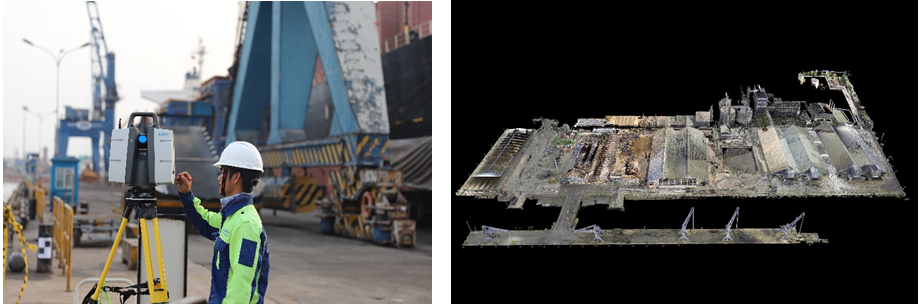
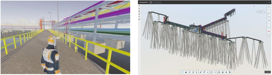
To implement this policy and solution, the Vung Tau Maritime Port Authority proactively provided Portcoast with information and data on the port (port construction design files, maritime traffic flow, detailed data on types of ships passing through Vung Tau port, maritime conditions in the area, etc.), as well as information on the nearly 50 ports, mooring areas, and floating docks in the management area. They collaborated with Portcoast to conduct surveys, gather necessary data, and organize work, mobilizing port companies operating in the cooperation area to provide data related to design/conversion/upgrading of port bridges, waterfront areas, etc., to ensure sufficient necessary data and create conditions for Portcoast to use Digital Twin - a "twin" of the physical environment in the digital space, such as a 3D model of the port or infrastructure project - data generated throughout the project life cycle from survey, design, construction to operation, exploitation, and maintenance. However, unlike static data models, the Digital Twin model is "alive," automatically collecting real-time data through sensors, cameras, connected via the Internet of Things (IoT) network, and integrating artificial intelligence (AI). The project also applied Building Information Modeling (BIM) and Scan-to-BIM technology (using modern technologies such as 3D laser scanners, mobile mapping, or aerial mapping) to accurately record the current state of structural objects, ship traffic flow, and detailed port planning in the form of point cloud clusters (Pointcloud is a collection of millions of accurately reflected points in the real environment, with coordinates in 3D space X, Y, Z, and color parameters, to become a reliable reference object for building digital models), to build and manage most of the port bridge and ship traffic flow models at Vung Tau seaport, through the following solutions:

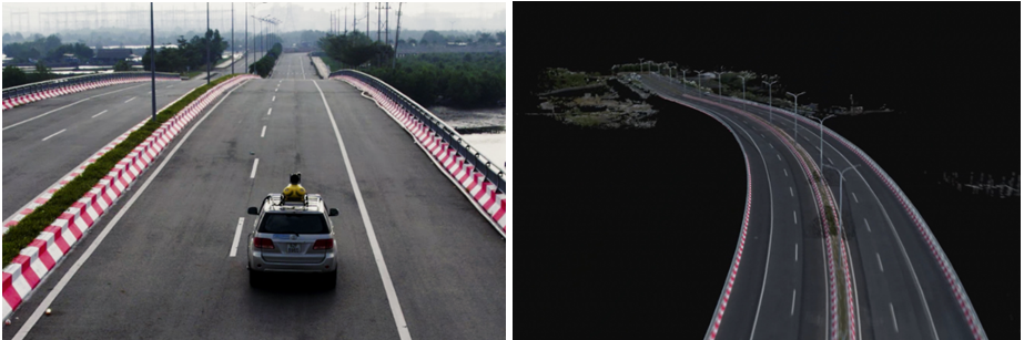
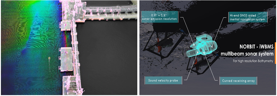
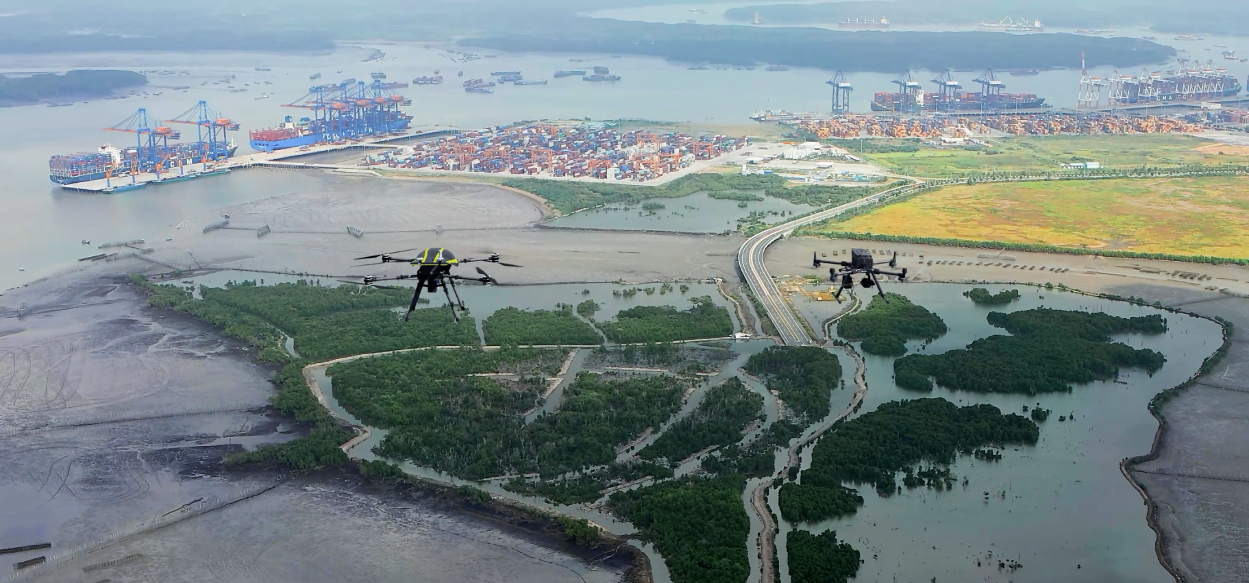
- The 3D laser mobile mapping solution is applied, using a 3D laser scanner device with integrated GPS mounted on a motorized vehicle to collect data while moving, and utilizing an Unmanned Surface Vehicle (USV) equipped with devices including the NORBIT iLidar 3D laser scanner placed on the bow of the vessel to record data around it, and a NORBIT iWBMS device mounted under the vessel to record seabed and riverbed terrain. This synchronized solution enables quick and accurate data collection both onshore and underwater.
- Aerial mapping is used to complete the data collection system, utilizing a 3D laser scanner device to quickly and accurately record panoramic data without obstacles. Portcoast uses two renowned devices for this purpose, the Stormbee integrating the Faro S350-A scanner and the DJI Matrice 300 RTK integrating the Zenmuse L1/P1/Share module.
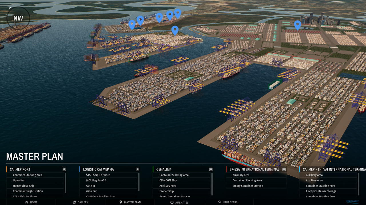
- Setting up data for the model: The 3 solutions provide a comprehensive and adaptable set of solutions for all terrain scale requirements. Based on collected data, the 3D modeling process of the construction from point clouds is performed in Autodesk Revit software and 3D laser scanner manufacturer support software. The digitized model is completed and applied to asset information management, building virtual port tour models, and most importantly, developing a digital twin.
As the gateway and international container transshipment port, Vung Tau seaport plays a significant role in Vietnam's seaport system. Therefore, actively coordinating research and completing the initial digitization of the planning, management, and operation of the port has great significance in terms of technological application and practical needs. This will help state management agencies, investors, operators, and related businesses manage and operate the seaport more effectively. Digitization will maximize operational capacity, improve operational safety, minimize environmental impact, and integrate the port system into the development process of the global maritime transportation ecosystem. In the future, the digital model will allow the reproduction of what is happening in the port system, establish scenarios for simulating all port activities, such as traffic activities, and possible emergency situations. From there, developing response scenarios and moving towards a comprehensive seaport management system to meet the trend of smart port development in the Industry 4.0 era... This is a great effort of Portcoast Company, as well as related agencies and units, and completing the "digitization of Vung Tau seaport" soon will be a prerequisite for evaluating effectiveness, drawing experience, and moving towards experimental application in important seaports nationwide.
Portcoast Digital Transformation Center
We provide digital conversion services in the construction industry. We research ways to apply digital conversion to the world of design and construction, creating a digital platform to optimize design, promote industrial construction processes, and use digital models.
Contact Us
328 Nguyen Trong Tuyen Str., Ward 2, Tan Binh Dist. , Ho Chi Minh City
(84 - 28) 62970345; 62970341
portcoast@portcoast.com.vn